
Make a donation
Prats-de-Mollo-la-Preste topographic map
Click on the map to display elevation.
Make a donation
Prats-de-Mollo-la-Preste
Prats-de-Mollo-la-Preste is located in the Pyrenees, 13 km (8.1 mi) from the Spanish border and the Autonomous Community of Catalonia, on the banks of the river Tech, and on the south face of the Canigou at an elevation of 735 meters.
Make a donation
About this map
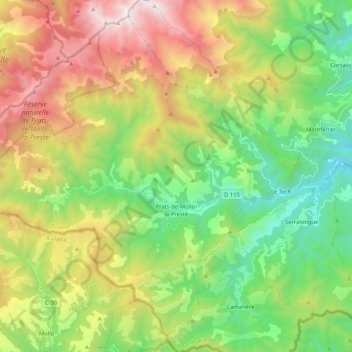
Name: Prats-de-Mollo-la-Preste topographic map, elevation, terrain.
Average elevation: 1,295 m
Minimum elevation: 416 m
Maximum elevation: 2,721 m
Make a donation
Other topographic maps
Click on a map to view its topography, its elevation and its terrain.
Pic de Finestrelles
France > Occitania > Pyrénées-Orientales > Eyne
Pic de Finestrelles is a mountain located in the Oriental Pyrenees, on the border of France and Spain. It has an altitude of 2,826 metres (9,272 ft) above sea level.
Average elevation: 2,502 m
Pic de Finestrelles
France > Occitania > Pyrénées-Orientales > Eyne
Pic de Finestrelles is a mountain located in the Oriental Pyrenees, on the border of France and Spain. It has an altitude of 2,826 metres (9,272 ft) above sea level.
Average elevation: 2,502 m
Make a donation
Make a donation
La Ville
France > Occitania > Pyrénées-Orientales > Saint-Laurent-de-la-Salanque
Average elevation: 4 m
Make a donation
Station de Puyvalador
France > Occitania > Pyrénées-Orientales > Puyvalador
Average elevation: 1,768 m
Make a donation