
Make a donation
Dinder topographic map
Click on the map to display elevation.
Make a donation
About this map
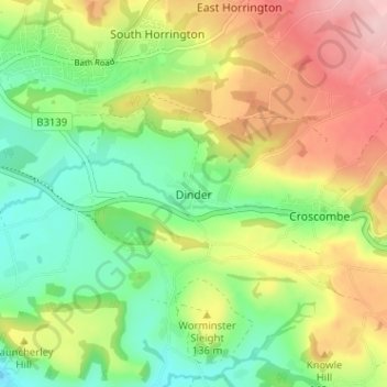
Name: Dinder topographic map, elevation, terrain.
Location: Dinder, Somerset, England, BA5 3PD, United Kingdom (51.17904 -2.62834 51.21904 -2.58834)
Average elevation: 100 m
Minimum elevation: 16 m
Maximum elevation: 215 m
Make a donation
Other topographic maps
Click on a map to view its topography, its elevation and its terrain.
Quantock Hills National Landscape
United Kingdom > England > Somerset > Over Stowey
Average elevation: 116 m
Make a donation
Make a donation
Make a donation
Make a donation
Make a donation
Make a donation
Make a donation
Make a donation
Mells Park
United Kingdom > England > Somerset > Vobster
The architect Edwin Lutyens had known the Horners, and Mells Park, since 1896. In 1918 he unsuccessfully tried to persuade the Horners to rebuild Park House. However, Reginald McKenna, the chairman of Midland Bank, and formerly Home Secretary and Chancellor of the Exchequer under Asquith, was married to Pamela…
Average elevation: 134 m
Make a donation
Make a donation
Make a donation
Make a donation
Make a donation
Make a donation
Make a donation
Brompton Ralph
United Kingdom > England > Somerset > Somerset West and Taunton
Average elevation: 224 m
Make a donation
Small Brook
United Kingdom > England > Somerset > South Somerset > Haselbury Plucknett
Average elevation: 48 m
Make a donation
St. Michael's Tower
United Kingdom > England > Somerset > Mendip District > Glastonbury
Average elevation: 33 m
Wiveliscombe
United Kingdom > England > Somerset
Wiveliscombe is a former borough, market and cloth making town,[18] 5 miles (8 km) from the border between Devon and Somerset. It is situated at the foot of the Brendon Hills and acts as a gateway to Exmoor. At an altitude of 126 m (413 ft) Wiveliscombe is the highest town in Somerset after Dulverton.
Average elevation: 166 m
Make a donation
Make a donation
Make a donation
Make a donation
Make a donation
Make a donation
Make a donation
Make a donation