
Thank you for supporting this site ❤️
Make a donation
Make a donation
Arakulam topographic map
Click on the map to display elevation.
Thank you for supporting this site ❤️
Make a donation
Make a donation
About this map
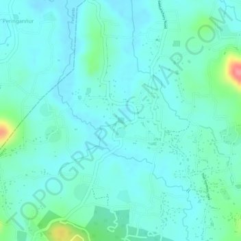
Name: Arakulam topographic map, elevation, terrain.
Location: Arakulam, Talappilly, Thrissur District, Kerala, India (10.73687 76.19624 10.73767 76.19701)
Average elevation: 34 m
Minimum elevation: 14 m
Maximum elevation: 110 m
Thank you for supporting this site ❤️
Make a donation
Make a donation
Other topographic maps
Click on a map to view its topography, its elevation and its terrain.
Thank you for supporting this site ❤️
Make a donation
Make a donation
Thank you for supporting this site ❤️
Make a donation
Make a donation
Thank you for supporting this site ❤️
Make a donation
Make a donation