
La Samme topographic map
Interactive map
Click on the map to display elevation.
About this map
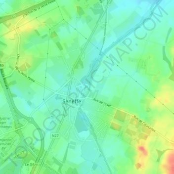
Name: La Samme topographic map, elevation, terrain.
Location: La Samme, Seneffe, Charleroi, Hainaut, Wallonie, 7180, Belgique (50.53073 4.25956 50.53212 4.26046)
Average elevation: 122 m
Minimum elevation: 105 m
Maximum elevation: 155 m
Other topographic maps
Click on a map to view its topography, its elevation and its terrain.
Petit-Roeulx-lez-Nivelles
Petit-Roeulx-lez-Nivelles, Seneffe, Charleroi, Hainaut, Wallonie, 7181, Belgique
Average elevation: 141 m
Familleureux
Familleureux, Seneffe, Hainaut, Wallonie, 7181, Belgique
Average elevation: 120 m
Château de Miremont
Château de Miremont, 20, Chaussée de Marche, Feluy, Seneffe, Charleroi, Hainaut, Wallonie, 7181, Belgique
Average elevation: 108 m