
Thank you for supporting this site ❤️
Make a donation
Make a donation
Brünen topographic map
Click on the map to display elevation.
Thank you for supporting this site ❤️
Make a donation
Make a donation
Brünen
Brünen liegt südöstlich von Hamminkeln auf einer Höhe zwischen 35 und 50 m ü. NHN, was in der Region Niederrhein bereits als höhere Lage bezeichnet werden kann. In Ortsnähe treffen sich die Bundesstraße 70, die Landesstraßen 1 und 480 sowie die Kreisstraße 26.
Thank you for supporting this site ❤️
Make a donation
Make a donation
About this map
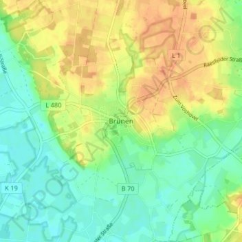
Name: Brünen topographic map, elevation, terrain.
Average elevation: 38 m
Minimum elevation: 22 m
Maximum elevation: 57 m
Thank you for supporting this site ❤️
Make a donation
Make a donation
Other topographic maps
Click on a map to view its topography, its elevation and its terrain.