
Make a donation
Tibubeneng topographic map
Click on the map to display elevation.
Make a donation
About this map
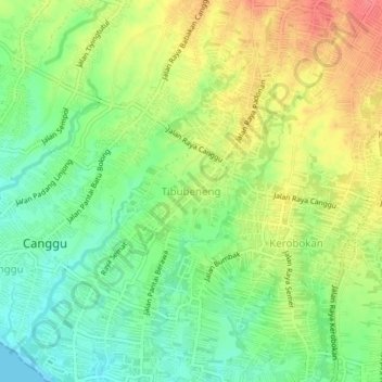
Name: Tibubeneng topographic map, elevation, terrain.
Location: Tibubeneng, Badung, Bali, 80351, Indonesia (-8.66518 115.13200 -8.62518 115.17200)
Average elevation: 30 m
Minimum elevation: 0 m
Maximum elevation: 65 m
Make a donation
Other topographic maps
Click on a map to view its topography, its elevation and its terrain.
Ayung River
The Ayung River watershed area has an annual average temperature between 18.4 °C and 26.6 °C, depending on the altitude. The average annual rainfall at the upstream is high, around 1963–3242 mm. Going downstream at an average inclination of 13.13%, the rainfall and the rainy days on the river decrease. In…
Average elevation: 444 m
Make a donation
Pecatu
Pecatu is located in South Kuta District of the Badung Regency. It is at the western end of the Bukit Peninsula in south Bali, and has a hilly topography with limestone cliffs isolating small, short beaches that have been privately developed. Nusa Dua, on the opposite side of the peninsula, is flat and is a…
Average elevation: 65 m