
Thank you for supporting this site ❤️
Make a donation
Make a donation
Hochfirst topographic map
Click on the map to display elevation.
Thank you for supporting this site ❤️
Make a donation
Make a donation
Hochfirst
Der Hochfirst ist ein bewaldeter Berg zwischen Saig und Titisee-Neustadt im Südschwarzwald mit einer Höhe von 1196,9 m ü. NHN.
Thank you for supporting this site ❤️
Make a donation
Make a donation
About this map
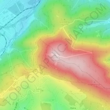
Name: Hochfirst topographic map, elevation, terrain.
Average elevation: 994 m
Minimum elevation: 826 m
Maximum elevation: 1,192 m
Thank you for supporting this site ❤️
Make a donation
Make a donation
Other topographic maps
Click on a map to view its topography, its elevation and its terrain.
Raitenbuch
Deutschland > Baden-Württemberg > Landkreis Breisgau-Hochschwarzwald > Lenzkirch
Average elevation: 996 m