Thank you for supporting this site ❤️
Make a donation
Make a donation
Loose topographic map
Click on the map to display elevation.
Thank you for supporting this site ❤️
Make a donation
Make a donation
About this map
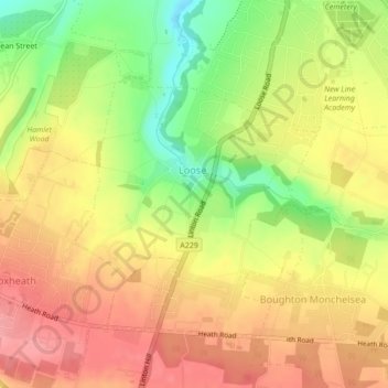
Name: Loose topographic map, elevation, terrain.
Location: Loose, Maidstone, Kent, England, United Kingdom (51.22971 0.50359 51.25821 0.54063)
Average elevation: 83 m
Minimum elevation: 12 m
Maximum elevation: 130 m
Thank you for supporting this site ❤️
Make a donation
Make a donation
Other topographic maps
Click on a map to view its topography, its elevation and its terrain.
Thank you for supporting this site ❤️
Make a donation
Make a donation
Thank you for supporting this site ❤️
Make a donation
Make a donation
Thank you for supporting this site ❤️
Make a donation
Make a donation
Thank you for supporting this site ❤️
Make a donation
Make a donation
The Hernitage and High Noon Farm
United Kingdom > England > Kent > Maidstone > Detling
Average elevation: 145 m
Thank you for supporting this site ❤️
Make a donation
Make a donation
