
Thank you for supporting this site ❤️
Make a donation
Make a donation
Estes topographic map
Click on the map to display elevation.
Thank you for supporting this site ❤️
Make a donation
Make a donation
About this map
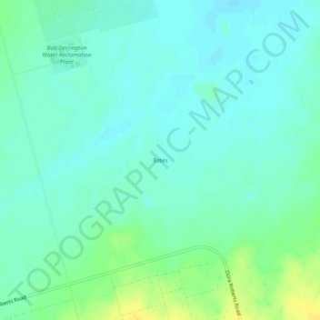
Name: Estes topographic map, elevation, terrain.
Location: Estes, Midland County, Texas, United States (31.78730 -102.26134 31.82730 -102.22134)
Average elevation: 862 m
Minimum elevation: 855 m
Maximum elevation: 878 m
Thank you for supporting this site ❤️
Make a donation
Make a donation
Other topographic maps
Click on a map to view its topography, its elevation and its terrain.
Chris Davidson Opportunity Park
United States > Texas > Midland County > Midland
Average elevation: 870 m