
Thank you for supporting this site ❤️
Make a donation
Make a donation
L'Echaillon topographic map
Click on the map to display elevation.
Thank you for supporting this site ❤️
Make a donation
Make a donation
About this map
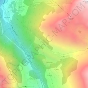
Name: L'Echaillon topographic map, elevation, terrain.
Average elevation: 1,941 m
Minimum elevation: 1,072 m
Maximum elevation: 2,903 m
Thank you for supporting this site ❤️
Make a donation
Make a donation
Other topographic maps
Click on a map to view its topography, its elevation and its terrain.
Glacier de la Sassière
France > Auvergne-Rhône-Alpes > Savoie > Sainte-Foy-Tarentaise
Average elevation: 3,165 m