
Thank you for supporting this site ❤️
Make a donation
Make a donation
Les Granges topographic map
Click on the map to display elevation.
Thank you for supporting this site ❤️
Make a donation
Make a donation
About this map
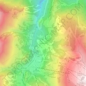
Name: Les Granges topographic map, elevation, terrain.
Average elevation: 1,725 m
Minimum elevation: 1,130 m
Maximum elevation: 2,340 m
Thank you for supporting this site ❤️
Make a donation
Make a donation
Other topographic maps
Click on a map to view its topography, its elevation and its terrain.
Refuge des Aiguilles d'Arves
France > Auvergne-Rhône-Alpes > Savoie > Valloire
Average elevation: 2,500 m
Combe de Beaujournal
France > Auvergne-Rhône-Alpes > Savoie > Valloire > Les Choseaux-Verneys
Average elevation: 2,012 m
Thank you for supporting this site ❤️
Make a donation
Make a donation