
Make a donation
Sproat Lake topographic map
Click on the map to display elevation.
Make a donation
About this map
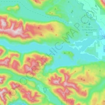
Name: Sproat Lake topographic map, elevation, terrain.
Average elevation: 386 m
Minimum elevation: 9 m
Maximum elevation: 1,328 m
Make a donation
Other topographic maps
Click on a map to view its topography, its elevation and its terrain.
Klitsa Mountain
Canada > British Columbia > Alberni-Clayoquot Regional District > Area D (Sproat Lake)
Average elevation: 1,108 m
View Lake
Canada > British Columbia > Alberni-Clayoquot Regional District > Area D (Sproat Lake)
Average elevation: 393 m
5040 Peak
Canada > British Columbia > Alberni-Clayoquot Regional District > Area D (Sproat Lake)
Average elevation: 1,092 m
Love Lake
Canada > British Columbia > Alberni-Clayoquot Regional District > Area D (Sproat Lake)
Average elevation: 1,338 m
Make a donation
Comox Glacier
Canada > British Columbia > Alberni-Clayoquot Regional District > Area D (Sproat Lake)
Average elevation: 1,584 m
Great Central
Canada > British Columbia > Alberni-Clayoquot Regional District > Area D (Sproat Lake)
Average elevation: 158 m
Comox Glacier
Canada > British Columbia > Alberni-Clayoquot Regional District > Area D (Sproat Lake)
Average elevation: 1,584 m