
Thank you for supporting this site ❤️
Make a donation
Make a donation
Sindelfingen topographic map
Click on the map to display elevation.
Thank you for supporting this site ❤️
Make a donation
Make a donation
About this map
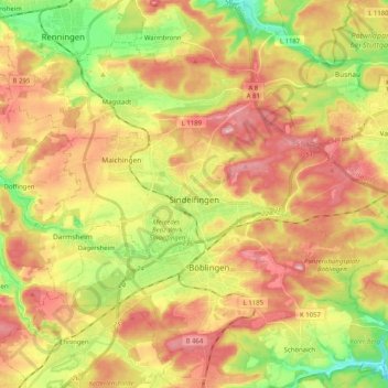
Name: Sindelfingen topographic map, elevation, terrain.
Location: Sindelfingen, Landkreis Böblingen, Baden-Württemberg, Germany (48.67376 8.90477 48.74688 9.10850)
Average elevation: 460 m
Minimum elevation: 362 m
Maximum elevation: 549 m
Thank you for supporting this site ❤️
Make a donation
Make a donation
Other topographic maps
Click on a map to view its topography, its elevation and its terrain.
Merklingen
Germany > Baden-Württemberg > Landkreis Böblingen > Weil der Stadt
Average elevation: 436 m