
Thank you for supporting this site ❤️
Make a donation
Make a donation
Carahue topographic map
Click on the map to display elevation.
Thank you for supporting this site ❤️
Make a donation
Make a donation
About this map
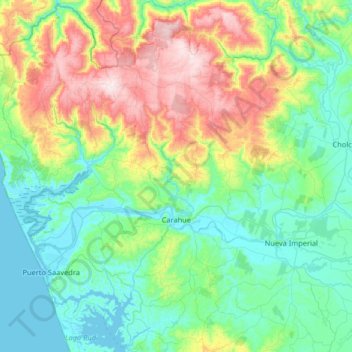
Name: Carahue topographic map, elevation, terrain.
Location: Carahue, Provincia de Cautín, Araucanía Region, Chile (-38.90261 -73.51907 -38.39419 -73.04947)
Average elevation: 218 m
Minimum elevation: -2 m
Maximum elevation: 861 m
Thank you for supporting this site ❤️
Make a donation
Make a donation
Other topographic maps
Click on a map to view its topography, its elevation and its terrain.
Thank you for supporting this site ❤️
Make a donation
Make a donation
Volcán Llaima
Chile > Araucanía Region > Provincia de Cautín > Vilcún
The average elevation of the terrain around Llaima is about 740 m asl.
Average elevation: 2,519 m
Thank you for supporting this site ❤️
Make a donation
Make a donation