
Make a donation
Qanateghestan topographic map
Click on the map to display elevation.
Make a donation
About this map
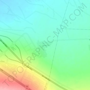
Name: Qanateghestan topographic map, elevation, terrain.
Location: Qanateghestan, بخش ماهان, Kerman County, Kerman Province, Iran (30.05810 57.21315 30.09810 57.25315)
Average elevation: 1,857 m
Minimum elevation: 1,821 m
Maximum elevation: 1,941 m
Make a donation
Other topographic maps
Click on a map to view its topography, its elevation and its terrain.
Kerman
Iran > Kerman Province > Kerman County
Kerman is located on a high margin of Kavir-e Lut (Lut Desert) in the south-central part of Iran. The city is surrounded by mountains. Kerman is also located along the Saheb Al Zaman mountain. The city is 1,755 m (5,758 ft) above sea level, making it third in elevation among provincial capitals in Iran. Winter…
Average elevation: 1,784 m
Make a donation
Make a donation
Lut Desert
Iran > Kerman Province > Kerman County > دهستان تکاب
The eastern part of Dasht-e Lut is a low plateau covered with salt flats with lowest elevations around 110 m above sea level (30.398609 N, 58.493041 E). In contrast, the center has been sculpted by the wind into a series of parallel ridges and furrows, extending over 150 km (93 mi) and reaching 75 metres (246…
Average elevation: 709 m
Make a donation