
Thank you for supporting this site ❤️
Make a donation
Make a donation
Le Bas Pampin topographic map
Click on the map to display elevation.
Thank you for supporting this site ❤️
Make a donation
Make a donation
About this map
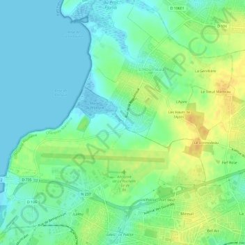
Name: Le Bas Pampin topographic map, elevation, terrain.
Average elevation: 11 m
Minimum elevation: -5 m
Maximum elevation: 29 m
Thank you for supporting this site ❤️
Make a donation
Make a donation
Other topographic maps
Click on a map to view its topography, its elevation and its terrain.
Plage de Chef de Baie
France > Nouvelle-Aquitaine > Charente-Maritime > La Rochelle
Average elevation: 3 m
Parc Frank Delmas
France > Nouvelle-Aquitaine > Charente-Maritime > La Rochelle
Average elevation: 6 m