
Thank you for supporting this site ❤️
Make a donation
Make a donation
Fleming Island topographic map
Click on the map to display elevation.
Thank you for supporting this site ❤️
Make a donation
Make a donation
About this map
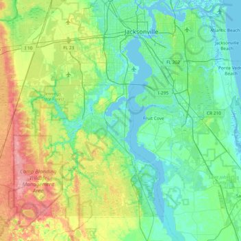
Name: Fleming Island topographic map, elevation, terrain.
Location: Fleming Island, Clay County, Florida, 32003, United States (29.77330 -82.03898 30.41330 -81.39898)
Average elevation: 19 m
Minimum elevation: -3 m
Maximum elevation: 79 m
Thank you for supporting this site ❤️
Make a donation
Make a donation
Other topographic maps
Click on a map to view its topography, its elevation and its terrain.