
Thank you for supporting this site ❤️
Make a donation
Make a donation
Surakan topographic map
Click on the map to display elevation.
Thank you for supporting this site ❤️
Make a donation
Make a donation
About this map
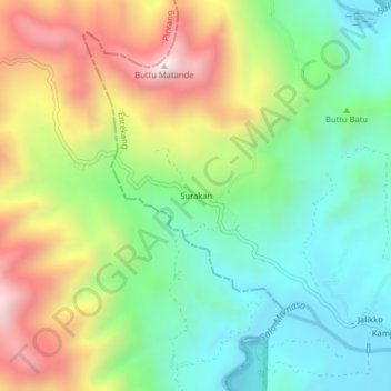
Name: Surakan topographic map, elevation, terrain.
Location: Surakan, Enrekang, South Sulawesi, Sulawesi, Indonesia (-3.48120 119.67719 -3.44120 119.71719)
Average elevation: 417 m
Minimum elevation: 81 m
Maximum elevation: 966 m
Thank you for supporting this site ❤️
Make a donation
Make a donation
Other topographic maps
Click on a map to view its topography, its elevation and its terrain.
Thank you for supporting this site ❤️
Make a donation
Make a donation
Thank you for supporting this site ❤️
Make a donation
Make a donation