
Thank you for supporting this site ❤️
Make a donation
Make a donation
Parnell topographic map
Click on the map to display elevation.
Thank you for supporting this site ❤️
Make a donation
Make a donation
About this map
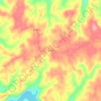
Name: Parnell topographic map, elevation, terrain.
Location: Parnell, Wayne County, Kentucky, United States (36.84785 -84.96523 36.88785 -84.92523)
Average elevation: 290 m
Minimum elevation: 205 m
Maximum elevation: 340 m
Thank you for supporting this site ❤️
Make a donation
Make a donation