
Make a donation
Mayland topographic map
Click on the map to display elevation.
Make a donation
About this map
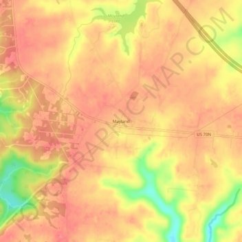
Name: Mayland topographic map, elevation, terrain.
Average elevation: 597 m
Minimum elevation: 549 m
Maximum elevation: 614 m
Make a donation
Other topographic maps
Click on a map to view its topography, its elevation and its terrain.
Crossville
United States > Tennessee > Cumberland County
Crossville is located at the center of Cumberland County at 35°57′15″N 85°1′53″W / 35.95417°N 85.03139°W / 35.95417; -85.03139 (35.954221, -85.031267). The city is situated atop the Cumberland Plateau amidst the headwaters of the Obed River, which slices a gorge north of Crossville en…
Average elevation: 553 m
Cumberland Mountain State Park
United States > Tennessee > Cumberland County > Crossville
Average elevation: 554 m
Fairfield Glade
United States > Tennessee > Cumberland County > Fairfield Glade
Average elevation: 542 m
Make a donation
Crossville
United States > Tennessee > Cumberland County
Crossville is located at the center of Cumberland County at 35°57′15″N 85°1′53″W / 35.95417°N 85.03139°W / 35.95417; -85.03139 (35.954221, -85.031267). The city is situated atop the Cumberland Plateau amid the headwaters of the Obed River, which slices a gorge north of Crossville en route…
Average elevation: 553 m
Make a donation