
Thank you for supporting this site ❤️
Make a donation
Make a donation
Thalwil topographic map
Click on the map to display elevation.
Thank you for supporting this site ❤️
Make a donation
Make a donation
About this map
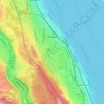
Name: Thalwil topographic map, elevation, terrain.
Location: Thalwil, Bezirk Horgen, Zurich, 8800, Switzerland (47.27273 8.54230 47.30631 8.58966)
Average elevation: 465 m
Minimum elevation: 401 m
Maximum elevation: 613 m
Thank you for supporting this site ❤️
Make a donation
Make a donation
Other topographic maps
Click on a map to view its topography, its elevation and its terrain.