
Make a donation
South Berwick topographic map
Click on the map to display elevation.
Make a donation
South Berwick
According to the United States Census Bureau, the town has a total area of 32.64 square miles (84.54 km2), of which 32.13 square miles (83.22 km2) is land and 0.51 square miles (1.32 km2) water. Located beside the New Hampshire border, South Berwick is drained by the Great Works River and Salmon Falls River. Welch Hill, elevation 370 feet (112.8 m) above sea level, is the town's highest point. The lowest elevation, which is sea level, is located along the Salmon Falls River, from the small hydroelectric dam next to the New Hampshire Route 4 bridge, south to the town's border with Eliot.
Make a donation
About this map
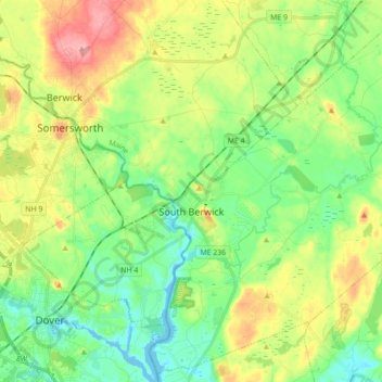
Name: South Berwick topographic map, elevation, terrain.
Location: South Berwick, York County, Maine, 03908, United States (43.17975 -70.82830 43.30243 -70.65291)
Average elevation: 46 m
Minimum elevation: -8 m
Maximum elevation: 127 m
Make a donation
Other topographic maps
Click on a map to view its topography, its elevation and its terrain.
Make a donation
Make a donation