
Thank you for supporting this site ❤️
Make a donation
Make a donation
B 500 topographic map
Click on the map to display elevation.
Thank you for supporting this site ❤️
Make a donation
Make a donation
About this map
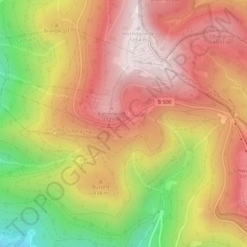
Name: B 500 topographic map, elevation, terrain.
Average elevation: 891 m
Minimum elevation: 494 m
Maximum elevation: 1,163 m
Thank you for supporting this site ❤️
Make a donation
Make a donation
Other topographic maps
Click on a map to view its topography, its elevation and its terrain.
Mummelsee
Deutschland > Baden-Württemberg > Ortenaukreis > Seebach
Der Mummelsee ist ein Karsee auf 1028,5 m ü. NN Höhe am Abhang der Hornisgrinde im Schwarzwald. Er ist 3,7 Hektar groß und 18 Meter tief. Er zählt zu den meistbesuchten Seen in Baden-Württemberg, da er direkt an der Schwarzwaldhochstraße liegt. Die touristischen Einrichtungen am See bilden den Wohnplatz…
Average elevation: 922 m