Geolocate

Uyo topographic map

Interactive map

Click on the map to display elevation.

About this map

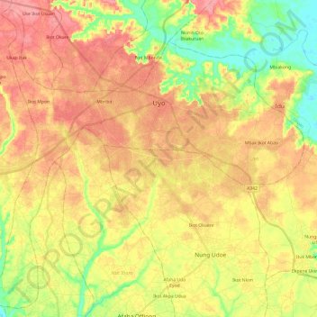
Name: Uyo topographic map, elevation, terrain.

Location: Uyo, Akwa Ibom State, Nigeria (4.87669 7.79431 5.10346 8.03516)

Average elevation: 50 m

Minimum elevation: 3 m

Maximum elevation: 89 m

Other topographic maps

Click on a map to view its topography, its elevation and its terrain.

Oruk Anam

Nigeria > Akwa Ibom State

Oruk Anam, Akwa Ibom State, Nigeria

Average elevation: 31 m

Nkwot Ikot Umo

Nigeria > Akwa Ibom State > Ikono > Nkwot Ikot Umo

Nkwot Ikot Umo, Ikono, Akwa Ibom State, Nigeria

Average elevation: 72 m

Abak

Nigeria > Akwa Ibom State > Abak

Abak, Akwa Ibom State, Nigeria

Average elevation: 57 m

Ibeno

Nigeria > Akwa Ibom State

Ibeno, Akwa Ibom State, Nigeria

Average elevation: 9 m