
Thank you for supporting this site ❤️
Make a donation
Make a donation
Les Adrets topographic map
Click on the map to display elevation.
Thank you for supporting this site ❤️
Make a donation
Make a donation
About this map
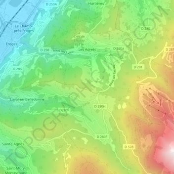
Name: Les Adrets topographic map, elevation, terrain.
Average elevation: 912 m
Minimum elevation: 223 m
Maximum elevation: 2,140 m
Thank you for supporting this site ❤️
Make a donation
Make a donation
Other topographic maps
Click on a map to view its topography, its elevation and its terrain.
Thank you for supporting this site ❤️
Make a donation
Make a donation
Le Col de l'Arzelier
France > Auvergne-Rhône-Alpes > Isère > Château-Bernard
Average elevation: 1,206 m
MontGaren
France > Auvergne-Rhône-Alpes > Isère > La Chapelle-du-Bard > MontGaren
Average elevation: 651 m
Thank you for supporting this site ❤️
Make a donation
Make a donation
Thank you for supporting this site ❤️
Make a donation
Make a donation
Les Gaudes
France > Auvergne-Rhône-Alpes > Isère > Saint-Pierre-de-Chartreuse
Average elevation: 1,062 m
Thank you for supporting this site ❤️
Make a donation
Make a donation
Thank you for supporting this site ❤️
Make a donation
Make a donation
Le Désert en Valjouffrey
France > Auvergne-Rhône-Alpes > Isère > Valjouffrey
Average elevation: 1,815 m