
Thank you for supporting this site ❤️
Make a donation
Make a donation
Wülfer-Bexten topographic map
Click on the map to display elevation.
Thank you for supporting this site ❤️
Make a donation
Make a donation
About this map
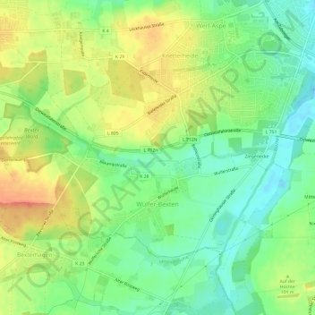
Name: Wülfer-Bexten topographic map, elevation, terrain.
Average elevation: 96 m
Minimum elevation: 75 m
Maximum elevation: 120 m
Thank you for supporting this site ❤️
Make a donation
Make a donation
Other topographic maps
Click on a map to view its topography, its elevation and its terrain.
Pillenbruch
Deutschland > Nordrhein-Westfalen > Kreis Lippe > Bad Salzuflen
Südlich von Pillenbruch befindet sich der 2001/2002 errichtete Windpark Pillenbruch. Die Energiequelle GmbH betreibt hier elf Windkraftanlagen – acht NEG Micon NM60/1000 / zwei Enercon E-58 / eine Nordex N80/2500, die Windenergie in elektrische Energie (12,5 MW) umwandeln. Die jeweils rund zwei Millionen…
Average elevation: 205 m
Vosshagen
Deutschland > Nordrhein-Westfalen > Kreis Lippe > Bad Salzuflen > Pillenbruch
Average elevation: 196 m
Thank you for supporting this site ❤️
Make a donation
Make a donation
Thank you for supporting this site ❤️
Make a donation
Make a donation