
Thank you for supporting this site ❤️
Make a donation
Make a donation
Big Bend topographic map
Click on the map to display elevation.
Thank you for supporting this site ❤️
Make a donation
Make a donation
About this map
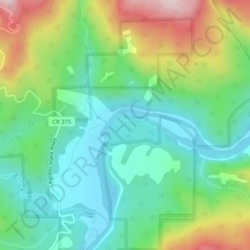
Name: Big Bend topographic map, elevation, terrain.
Location: Big Bend, Curry County, Oregon, United States (42.63430 -124.05521 42.65430 -124.03521)
Average elevation: 176 m
Minimum elevation: 45 m
Maximum elevation: 441 m
Thank you for supporting this site ❤️
Make a donation
Make a donation
Other topographic maps
Click on a map to view its topography, its elevation and its terrain.