
Thank you for supporting this site ❤️
Make a donation
Make a donation
Devecey topographic map
Click on the map to display elevation.
Thank you for supporting this site ❤️
Make a donation
Make a donation
About this map
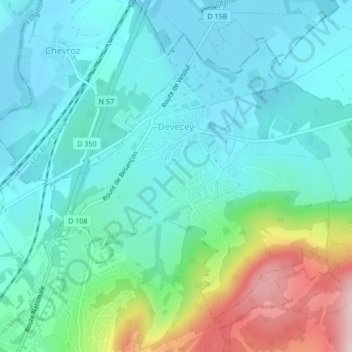
Name: Devecey topographic map, elevation, terrain.
Average elevation: 278 m
Minimum elevation: 213 m
Maximum elevation: 498 m
Thank you for supporting this site ❤️
Make a donation
Make a donation
Other topographic maps
Click on a map to view its topography, its elevation and its terrain.
Roche de Chatard
Frankrijk > Bourgondië-Franche-Comté > Doubs > Baume-les-Dames
Average elevation: 316 m
Thank you for supporting this site ❤️
Make a donation
Make a donation