
Thank you for supporting this site ❤️
Make a donation
Make a donation
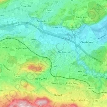
Uzwil topographic map
Click on the map to display elevation.
Thank you for supporting this site ❤️
Make a donation
Make a donation
Uzwil
Der Weiler mit 61 Einwohnern befindet sich auf einer Anhöhe zwischen Uzwil und der Strasse Oberuzwil–Flawil. In der Nähe befindet sich der Stolzenbergweiher. Von Uzwil oder Niederuzwil aus ist die Pappel-Allee, welche sich vor Stolzenberg oberhalb der Bahnlinie befindet, gut sichtbar.
Thank you for supporting this site ❤️
Make a donation
Make a donation
About this map
Name: Uzwil topographic map, elevation, terrain.
Location: Uzwil, Wahlkreis Wil, St. Gallen, Schweiz (47.42405 9.06608 47.46445 9.15653)
Average elevation: 571 m
Minimum elevation: 481 m
Maximum elevation: 799 m
Thank you for supporting this site ❤️
Make a donation
Make a donation
Other topographic maps
Click on a map to view its topography, its elevation and its terrain.