Geolocate

Enugu topographic map

Interactive map

Click on the map to display elevation.

About this map

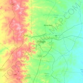
Name: Enugu topographic map, elevation, terrain.

Location: Enugu, Enugu North, Enugu State, 400261, Nigeria (6.28998 7.34000 6.60998 7.66000)

Average elevation: 234 m

Minimum elevation: 73 m

Maximum elevation: 589 m

Despite its name meaning hill top in the Igbo language, Enugu lies at the foot of an escarpment and not a hill. Enugu is located in the Cross River basin and the Benue trough and has the best developed coal in this area. Precambrian basement rock in this region is overlaid with sediments bearing coal from the Cretaceous and Tertiary age. Coal seams in the Enugu coal district measure between 1 and 2 metres (3.3 and 6.6 ft) in thickness and the reserves have been estimated to be more than 300 million tonnes. Enugu's hills at the extreme may reach an elevation of 1,000 metres (3,300 ft). Highlands surrounding Enugu for the most part are underlain by sandstone, while lowlands are underlain by shale. Much of the escarpment stretching from Enugu to Orlu has been ravaged by soil and gully erosion. Other geological features in Enugu include the Nike Lake near which the Nike Lake Hotel has been built. The Ekulu, Asata, Ogbete, Aria, Idaw and Nyaba rivers are the six largest rivers located in the city. The Ekulu River is the largest body of water in Enugu urban and its reservoir contributes to part of the city's domestic water supply.