
Thank you for supporting this site ❤️
Make a donation
Make a donation
Fort Chadbourne topographic map
Click on the map to display elevation.
Thank you for supporting this site ❤️
Make a donation
Make a donation
About this map
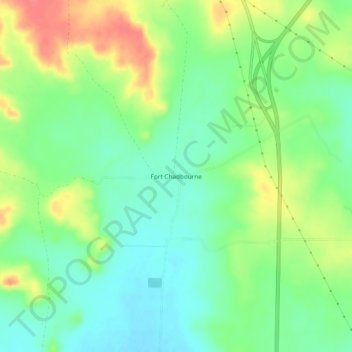
Name: Fort Chadbourne topographic map, elevation, terrain.
Location: Fort Chadbourne, Coke County, Texas, United States (31.98069 -100.30954 32.02069 -100.26954)
Average elevation: 615 m
Minimum elevation: 589 m
Maximum elevation: 655 m
Thank you for supporting this site ❤️
Make a donation
Make a donation
Other topographic maps
Click on a map to view its topography, its elevation and its terrain.