
Thank you for supporting this site ❤️
Make a donation
Make a donation
Benham topographic map
Click on the map to display elevation.
Thank you for supporting this site ❤️
Make a donation
Make a donation
About this map
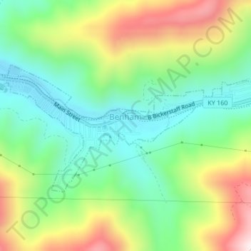
Name: Benham topographic map, elevation, terrain.
Location: Benham, Harlan County, Kentucky, 40807, United States (36.95671 -82.96813 36.97097 -82.93552)
Average elevation: 667 m
Minimum elevation: 460 m
Maximum elevation: 1,020 m
Thank you for supporting this site ❤️
Make a donation
Make a donation
Other topographic maps
Click on a map to view its topography, its elevation and its terrain.
Thank you for supporting this site ❤️
Make a donation
Make a donation
Thank you for supporting this site ❤️
Make a donation
Make a donation
Thank you for supporting this site ❤️
Make a donation
Make a donation
Thank you for supporting this site ❤️
Make a donation
Make a donation
Thank you for supporting this site ❤️
Make a donation
Make a donation
Harlan
United States > Kentucky > Harlan County > Harlan > Harlan
Harlan is located in west-central Harlan County at 36°50′29″N 83°19′12″W / 36.84139°N 83.32000°W / 36.84139; -83.32000 (36.841487, -83.320066), at the junction of the Clover Fork and Martin's Fork rivers. The Clover Fork continues north 1.5 miles (2.4 km) to join the Poor Fork, forming the…
Average elevation: 512 m
Thank you for supporting this site ❤️
Make a donation
Make a donation