
Brierwood Hills topographic map
Interactive map
Click on the map to display elevation.
About this map
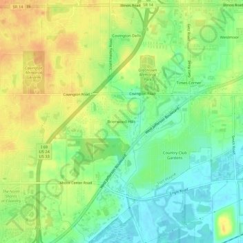
Name: Brierwood Hills topographic map, elevation, terrain.
Average elevation: 246 m
Minimum elevation: 228 m
Maximum elevation: 264 m
Other topographic maps
Click on a map to view its topography, its elevation and its terrain.
Times Corner
United States > Indiana > Allen County > Fort Wayne
Times Corner, Fort Wayne, Allen County, Indiana, 46804, United States
Average elevation: 244 m
Hillcrest
United States > Indiana > Allen County > Fort Wayne
Hillcrest, Fort Wayne, Allen County, Indiana, 48606, United States
Average elevation: 241 m
Anthony Wayne Village
United States > Indiana > Allen County > Fort Wayne
Anthony Wayne Village, Fort Wayne, Allen County, Indiana, 46806, United States
Average elevation: 244 m
Fort Wayne
United States > Indiana > Allen County > Fort Wayne
Fort Wayne, Allen County, Indiana, 46802, United States
Average elevation: 248 m