
Thank you for supporting this site ❤️
Make a donation
Make a donation
American Basin topographic map
Click on the map to display elevation.
Thank you for supporting this site ❤️
Make a donation
Make a donation
About this map
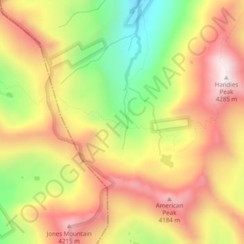
Name: American Basin topographic map, elevation, terrain.
Location: American Basin, Hinsdale County, Colorado, United States (37.89805 -107.52913 37.91805 -107.50913)
Average elevation: 3,930 m
Minimum elevation: 3,532 m
Maximum elevation: 4,265 m
Thank you for supporting this site ❤️
Make a donation
Make a donation
Other topographic maps
Click on a map to view its topography, its elevation and its terrain.