
Thank you for supporting this site ❤️
Make a donation
Make a donation
Quincieu topographic map
Click on the map to display elevation.
Thank you for supporting this site ❤️
Make a donation
Make a donation
About this map
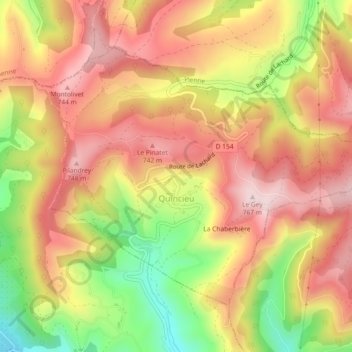
Name: Quincieu topographic map, elevation, terrain.
Average elevation: 631 m
Minimum elevation: 435 m
Maximum elevation: 766 m
Thank you for supporting this site ❤️
Make a donation
Make a donation
Other topographic maps
Click on a map to view its topography, its elevation and its terrain.
Les Beauches
Frankrijk > Auvergne-Rhône-Alpes > Isère > Le Sappey-en-Chartreuse
Average elevation: 1,072 m
Boulière
Frankrijk > Auvergne-Rhône-Alpes > Isère > Le Sappey-en-Chartreuse
Average elevation: 1,008 m
Thank you for supporting this site ❤️
Make a donation
Make a donation
Thank you for supporting this site ❤️
Make a donation
Make a donation
La Combe des Berards
Frankrijk > Auvergne-Rhône-Alpes > Isère > Saint-Georges-de-Commiers
Average elevation: 566 m
Thank you for supporting this site ❤️
Make a donation
Make a donation
Belvédère des Écrins
Frankrijk > Auvergne-Rhône-Alpes > Isère > Saint-Christophe-en-Oisans
Average elevation: 3,014 m
Thank you for supporting this site ❤️
Make a donation
Make a donation
Le Cornet
Frankrijk > Auvergne-Rhône-Alpes > Isère > Autrans-Méaudre en Vercors > Le Cornet
Average elevation: 1,165 m