
Thank you for supporting this site ❤️
Make a donation
Make a donation
Le Praz topographic map
Click on the map to display elevation.
Thank you for supporting this site ❤️
Make a donation
Make a donation
About this map
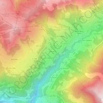
Name: Le Praz topographic map, elevation, terrain.
Average elevation: 1,364 m
Minimum elevation: 737 m
Maximum elevation: 1,965 m
Thank you for supporting this site ❤️
Make a donation
Make a donation
Other topographic maps
Click on a map to view its topography, its elevation and its terrain.
Refuge de la Croix de Pierre
France > Auvergne-Rhône-Alpes > Savoie > Hauteluce
Average elevation: 1,866 m