
Thank you for supporting this site ❤️
Make a donation
Make a donation
King Country topographic map
Click on the map to display elevation.
Thank you for supporting this site ❤️
Make a donation
Make a donation
About this map
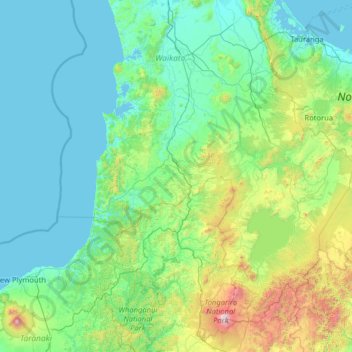
Name: King Country topographic map, elevation, terrain.
Location: King Country, Waitomo District, Waikato, New Zealand (-39.46595 174.21583 -37.46595 176.21583)
Average elevation: 296 m
Minimum elevation: 0 m
Maximum elevation: 2,717 m
Thank you for supporting this site ❤️
Make a donation
Make a donation
Other topographic maps
Click on a map to view its topography, its elevation and its terrain.