
Thank you for supporting this site ❤️
Make a donation
Make a donation
Le Champ Rouge topographic map
Click on the map to display elevation.
Thank you for supporting this site ❤️
Make a donation
Make a donation
About this map
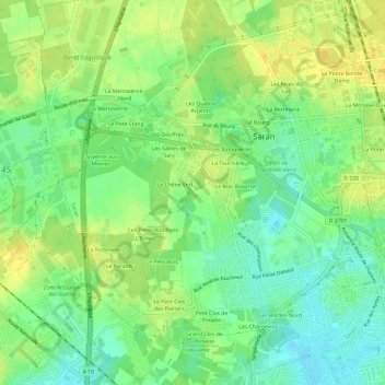
Name: Le Champ Rouge topographic map, elevation, terrain.
Average elevation: 121 m
Minimum elevation: 108 m
Maximum elevation: 133 m
Thank you for supporting this site ❤️
Make a donation
Make a donation
Other topographic maps
Click on a map to view its topography, its elevation and its terrain.
Lac de la Médecinerie
France > Centre-Val de Loire > Loiret > Saran > La Guignace
Average elevation: 122 m