
Keldenich topographic map
Interactive map
Click on the map to display elevation.
About this map
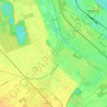
Name: Keldenich topographic map, elevation, terrain.
Average elevation: 58 m
Minimum elevation: 41 m
Maximum elevation: 69 m
Other topographic maps
Click on a map to view its topography, its elevation and its terrain.
Wesseling
Deutschland > Nordrhein-Westfalen > Wesseling
Wesseling, Rhein-Erft-Kreis, Regierungsbezirk Köln, Nordrhein-Westfalen, 50389, Deutschland
Average elevation: 53 m
Berzdorf
Deutschland > Nordrhein-Westfalen > Wesseling
Berzdorf, Wesseling, Rhein-Erft-Kreis, Regierungsbezirk Köln, Nordrhein-Westfalen, Deutschland
Average elevation: 57 m