
Thank you for supporting this site ❤️
Make a donation
Make a donation
Al Manzafah topographic map
Click on the map to display elevation.
Thank you for supporting this site ❤️
Make a donation
Make a donation
About this map
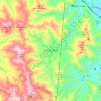
Name: Al Manzafah topographic map, elevation, terrain.
Location: Al Manzafah, Ras al-Khaimah, United Arab Emirates (25.06543 56.15609 25.14543 56.23609)
Average elevation: 539 m
Minimum elevation: 134 m
Maximum elevation: 1,033 m
Thank you for supporting this site ❤️
Make a donation
Make a donation
Other topographic maps
Click on a map to view its topography, its elevation and its terrain.
Wadi Kub
United Arab Emirates > Ras al-Khaimah > Kub
In its upper course, the wadi is formed by two arms of similar length and flow, which originate at approximately an altitude of 542 m (1,778 ft); they border Al Jaroof to the east and west, respectively; and converge to the south of this town, defining the main channel, which initially follows the direction…
Average elevation: 324 m
Thank you for supporting this site ❤️
Make a donation
Make a donation
Thank you for supporting this site ❤️
Make a donation
Make a donation