
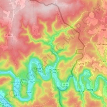
Les Hautes-Rivières topographic map
Interactive map
Click on the map to display elevation.
About this map
Name: Les Hautes-Rivières topographic map, elevation, terrain.
Average elevation: 337 m
Minimum elevation: 135 m
Maximum elevation: 508 m
Other topographic maps
Click on a map to view its topography, its elevation and its terrain.
La Neuville-aux-Haies
Frankrijk > Grand Est > Les Hautes-Rivières > La Neuville-aux-Haies
La Neuville-aux-Haies, Les Hautes-Rivières, Charleville-Mézières, Ardennes, Grand Est, Metropolitaans Frankrijk, 08800, Frankrijk
Average elevation: 402 m