
Thank you for supporting this site ❤️
Make a donation
Make a donation
Bathurst topographic map
Click on the map to display elevation.
Thank you for supporting this site ❤️
Make a donation
Make a donation
About this map
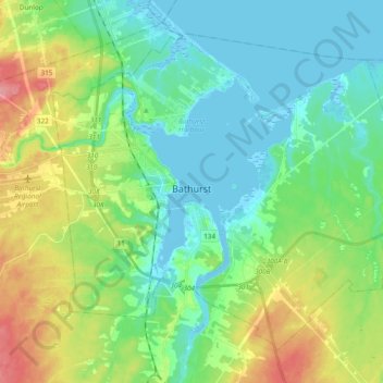
Name: Bathurst topographic map, elevation, terrain.
Location: Bathurst, Gloucester County, New Brunswick, Canada (47.57246 -65.72340 47.67852 -65.53333)
Average elevation: 26 m
Minimum elevation: -5 m
Maximum elevation: 86 m
Thank you for supporting this site ❤️
Make a donation
Make a donation
Other topographic maps
Click on a map to view its topography, its elevation and its terrain.
Thank you for supporting this site ❤️
Make a donation
Make a donation
Saint-Pons
Canada > New Brunswick > Gloucester County > Regional Municipality of Tracadie
Average elevation: 23 m