
Make a donation
Καλαμάκι topographic map
Click on the map to display elevation.
Make a donation
About this map
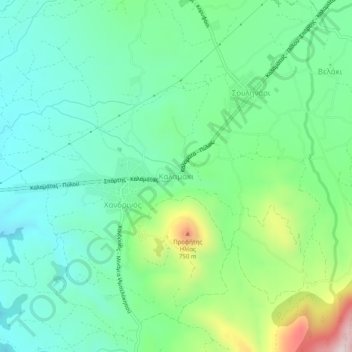
Name: Καλαμάκι topographic map, elevation, terrain.
Average elevation: 344 m
Minimum elevation: 195 m
Maximum elevation: 737 m
Make a donation
Other topographic maps
Click on a map to view its topography, its elevation and its terrain.
Proti
Greece > Peloponnese, Western Greece and the Ionian > Messenia Regional Unit > Gargalianoi Municipal Unit
Average elevation: 16 m
Palace of Nestor
Greece > Peloponnese, Western Greece and the Ionian > Messenia Regional Unit > Chora > Pisaski
Average elevation: 146 m
Municipality of Pylos and Nestor
Greece > Peloponnese, Western Greece and the Ionian > Messenia Regional Unit
Average elevation: 101 m
Sapientza
Greece > Peloponnese, Western Greece and the Ionian > Messenia Regional Unit > Methoni Municipal Unit
Average elevation: 15 m
Make a donation
Schiza
Greece > Peloponnese, Western Greece and the Ionian > Messenia Regional Unit > Methoni Municipal Unit
Average elevation: 20 m