
Make a donation
Otterbein topographic map
Click on the map to display elevation.
Make a donation
About this map
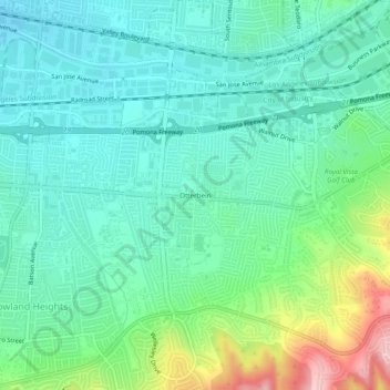
Name: Otterbein topographic map, elevation, terrain.
Average elevation: 171 m
Minimum elevation: 121 m
Maximum elevation: 315 m
Make a donation
Other topographic maps
Click on a map to view its topography, its elevation and its terrain.
Santa Monica Mountains
United States > California > Los Angeles County > Malibu
On January 17, 2007, an unusually cold storm brought snow in the Santa Monica Mountains. The hills above Malibu picked up three inches (eight centimeters) of snow - the first measurable snow in fifty years. Snow was reported on Boney Peak in the winter of 2005; and in March 2006, snow also fell on the summit…
Average elevation: 288 m
Hollywood Hills
United States > California > Los Angeles County > Los Angeles
Average elevation: 242 m
Make a donation
Make a donation
Highland Camrose Park
United States > California > Los Angeles County > Los Angeles
Average elevation: 186 m
Make a donation
San Clemente Island
United States > California > Los Angeles County
Its highest point is Mount Thirst, at 1965 feet in elevation. The elevation of the island's ridge can impact precipitation, as it can cause atmospheric moisture to condense and cause more intense precipitation. This was a factor in the intense rainstorm that hit San Diego on January 22, 2024.
Average elevation: 49 m
Make a donation
Make a donation