
Make a donation
Dallas County topographic map
Click on the map to display elevation.
Make a donation
About this map
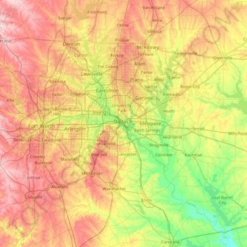
Name: Dallas County topographic map, elevation, terrain.
Location: Dallas County, Texas, United States (32.06204 -97.47901 33.46204 -96.07901)
Average elevation: 182 m
Minimum elevation: 78 m
Maximum elevation: 345 m
Make a donation
Other topographic maps
Click on a map to view its topography, its elevation and its terrain.
Franklin Mountains State Park
United States > Texas > El Paso County > El Paso
Franklin Mountains State Park is a Texas state park in El Paso, Texas, that protects the Franklin Mountains. Park headquarters are located at an elevation of 5,426 feet (1,654 m) with the highest peak, North Franklin Mountain, reaching 7,192 feet (2,192 m). It is one of the largest urban parks in the nation…
Average elevation: 1,293 m
Spring Valley
United States > Texas > Harris County
In 1936 state highway maps indicated a cemetery and a church. Initially the settlement consisted of one and one-half square miles.Spring Valley, once known as Lusk, is at the intersection of Farm roads 2416 and 2113, fourteen miles southwest of Waco in southwestern McLennan County. A post office, called Lusk…
Average elevation: 25 m
Make a donation
Lake Waco
United States > Texas > McLennan County > Waco
The average elevation of Lake Waco is held around 460 feet above sea level, with a typical fluctuation of 2–6 feet. Prior to the construction of the new dam, droughts and floods were common occurrences for the city of Waco. However, the new dam has proven to be the proper solution, as there has not been any…
Average elevation: 157 m
Make a donation
Lake Alan Henry
United States > Texas > Garza County
Lake Alan Henry is located on the Double Mountain Fork Brazos River in West Texas. South of Lubbock and east of Justiceburg, the lake extends 11 mi (18 km) and has over 56 mi (90 km) of shoreline. Its elevation is 1,000 ft (300 m) lower than the city of Lubbock. Lake Alan Henry has a maximum depth of 100 ft…
Average elevation: 707 m
Make a donation
Marfa
United States > Texas > Presidio County
Marfa is a city in the high desert of the Trans-Pecos in far West Texas, United States, between the Davis Mountains and Big Bend National Park, at an elevation of 4685 feet. It is the county seat of Presidio County, and its population as of the 2020 United States Census was 1,788. The city was founded in the…
Average elevation: 1,434 m
Make a donation
Honey Grove
United States > Texas > Fannin County
Honey Grove is in central North Texas, in eastern Fannin County, 16 miles (26 km) east of Bonham, the county seat, 39 miles (63 km) north of Greenville, 42 miles (68 km) east of Sherman, and 90 miles (140 km) northeast of the central business district of Dallas. Honey Grove was developed on flat to gently…
Average elevation: 195 m
Make a donation
Make a donation
Make a donation
Make a donation
Make a donation
Make a donation
Make a donation
Make a donation
Make a donation
Make a donation
Make a donation
Make a donation
Summerfields/Chisholm Park
United States > Texas > Tarrant County > Fort Worth
Average elevation: 203 m
Make a donation
Make a donation
Make a donation
Make a donation
Make a donation
Make a donation
Make a donation
Shavano Park
United States > Texas > Bexar County
Despite lying in the far southeastern reaches of the Texas Hill Country, Shavano Park's terrain is flat to gently rolling. Most of the city is between 950 and 1,000 feet above sea level, which contrasts sharply with neighborhoods just north of Anderson Loop, where hills can rise 200 feet in a short distance.…
Average elevation: 293 m
Make a donation
Make a donation