
Make a donation
Osternienburg topographic map
Click on the map to display elevation.
Make a donation
About this map
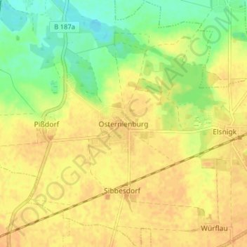
Name: Osternienburg topographic map, elevation, terrain.
Average elevation: 70 m
Minimum elevation: 52 m
Maximum elevation: 79 m
Make a donation
Other topographic maps
Click on a map to view its topography, its elevation and its terrain.
Diebzig
Deutschland > Sachsen-Anhalt > Anhalt-Bitterfeld > Osternienburger Land
Average elevation: 54 m
Libbesdorf
Deutschland > Sachsen-Anhalt > Anhalt-Bitterfeld > Osternienburger Land
Average elevation: 76 m
Kleinpaschleben
Deutschland > Sachsen-Anhalt > Anhalt-Bitterfeld > Osternienburger Land
Average elevation: 76 m
Dornbock
Deutschland > Sachsen-Anhalt > Anhalt-Bitterfeld > Osternienburger Land
Average elevation: 63 m
Make a donation
Großpaschleben
Deutschland > Sachsen-Anhalt > Anhalt-Bitterfeld > Osternienburger Land
Average elevation: 82 m
Micheln
Deutschland > Sachsen-Anhalt > Anhalt-Bitterfeld > Osternienburger Land > Trebbichau
Average elevation: 61 m
Wulfen
Deutschland > Sachsen-Anhalt > Anhalt-Bitterfeld > Osternienburger Land
Average elevation: 59 m
Make a donation