
Thank you for supporting this site ❤️
Make a donation
Make a donation
Wolferode topographic map
Click on the map to display elevation.
Thank you for supporting this site ❤️
Make a donation
Make a donation
About this map
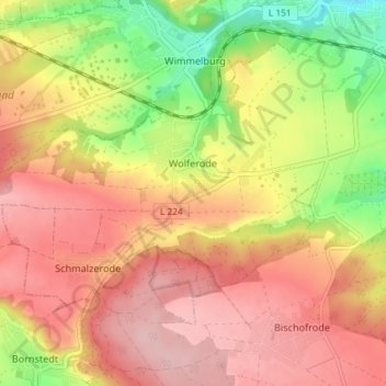
Name: Wolferode topographic map, elevation, terrain.
Average elevation: 236 m
Minimum elevation: 142 m
Maximum elevation: 300 m
Thank you for supporting this site ❤️
Make a donation
Make a donation
Other topographic maps
Click on a map to view its topography, its elevation and its terrain.
Hedersleben (b. Eisleben)
Deutschland > Sachsen-Anhalt > Mansfeld-Südharz > Lutherstadt Eisleben > Hedersleben (b. Eisleben)
Average elevation: 201 m