
Valle de Las Lagrimas topographic map
Interactive map
Click on the map to display elevation.
About this map
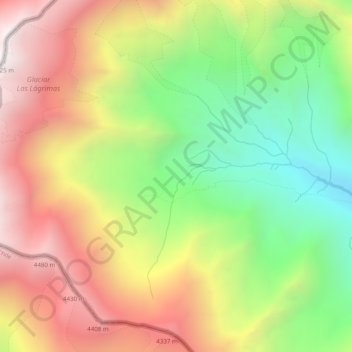
Name: Valle de Las Lagrimas topographic map, elevation, terrain.
Average elevation: 3,809 m
Minimum elevation: 3,036 m
Maximum elevation: 4,624 m
Other topographic maps
Click on a map to view its topography, its elevation and its terrain.
Las Leñas
Argentina > Mendoza > Distrito Ciudad de Malargüe
Las Leñas, Distrito Ciudad de Malargüe, Departamento Malargüe, Mendoza, 5612, Argentina
Average elevation: 2,393 m