
Thank you for supporting this site ❤️
Make a donation
Make a donation
Centerville topographic map
Click on the map to display elevation.
Thank you for supporting this site ❤️
Make a donation
Make a donation
About this map
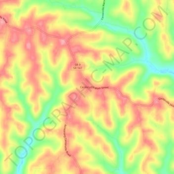
Name: Centerville topographic map, elevation, terrain.
Location: Centerville, Belmont County, Ohio, United States (39.95591 -80.98537 39.99591 -80.94537)
Average elevation: 362 m
Minimum elevation: 297 m
Maximum elevation: 409 m
Thank you for supporting this site ❤️
Make a donation
Make a donation
Other topographic maps
Click on a map to view its topography, its elevation and its terrain.
Thank you for supporting this site ❤️
Make a donation
Make a donation
Thank you for supporting this site ❤️
Make a donation
Make a donation
Thank you for supporting this site ❤️
Make a donation
Make a donation