
Thank you for supporting this site ❤️
Make a donation
Make a donation
Miesville topographic map
Click on the map to display elevation.
Thank you for supporting this site ❤️
Make a donation
Make a donation
About this map
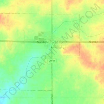
Name: Miesville topographic map, elevation, terrain.
Location: Miesville, Dakota County, Minnesota, United States (44.58801 -92.83294 44.60811 -92.80265)
Average elevation: 289 m
Minimum elevation: 268 m
Maximum elevation: 305 m
Thank you for supporting this site ❤️
Make a donation
Make a donation
Other topographic maps
Click on a map to view its topography, its elevation and its terrain.
Chimney Rock Scenic and Natural Area
United States > Minnesota > Dakota County
Average elevation: 269 m
Burnsville
United States > Minnesota > Dakota County > Burnsville > Burnsville
Average elevation: 275 m
Thank you for supporting this site ❤️
Make a donation
Make a donation
Pig's Eye Island Heron Rookery SNA
United States > Minnesota > Dakota County > South St. Paul
Average elevation: 221 m
Farmington
United States > Minnesota > Dakota County > Farmington > Farmington
Average elevation: 280 m
Thank you for supporting this site ❤️
Make a donation
Make a donation